

GetStarNews GetStarNews
Sign In
Live
Martinsville Desk

Distillery

...PASSING SHOWERS/STORMS INTO FRI NIGHT... ...MAINLY CLOUDY WITH MORNING SPRINKLES SAT... ***UPDATE: WIDESPREAD, SOAKING RAIN FINALLY POSSIBLE NEXT TUE-WED!*** Sponsored by The...

WeatherCategory
PUBLICVisibility
facebook_postSource type
PublishedStory status

...PASSING SHOWERS/STORMS INTO FRI NIGHT...

facebook.com | Sep 18, 2026 5:16 PM

...PASSING SHOWERS/STORMS INTO FRI NIGHT... ...MAINLY CLOUDY WITH MORNING SPRINKLES SAT... ***UPDATE: WIDESPREAD, SOAKING RAIN FINALLY POSSIBLE NEXT TUE-WED!***

Sponsored by The Kingery Team at Mountain to Lake Realty 540-420-2030

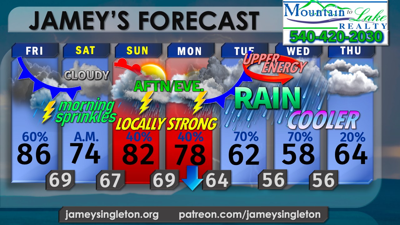
Changes to this forecast include: - Less severity to any storms today (Friday 9/18/26) - Limited any lingering moisture Sat. to the morning as rouge sprinkles, nudged highs up a touch by afternoon - More confidence in stronger storms both Sunday and Monday mainly from 2-9 p.m. both days - Much higher coverage of rain Tuesday and Wednesday with drastically cooler temps as a result

Let's hope the trends keep up as energy approaching into the weekend and next week continues to trend stronger, digging further south with time, which eventually closes off a low aloft early next week by Tuesday. That upper energy will interact with another back door cool front that will stall just to our south into Wednesday. The combo of easterly winds off the Atlantic and deeper gulf moisture getting pulled up into the upper low gives us an ideal setup for a steady, soaking rain early next week, perhaps on the order of 1-2" or more. Things can change but the trend is in our favor.

In the meantime, any rain will be from passing scattered showers and storms in some areas into tonight. Not everyone will see the storms, as we are still in the drier NW flow today. We haven't yet turned the corner on the dryness.

Energy that once appeared to stay north Sunday and Monday now looks to dip further south. There should be two waves of stronger storms as a result Sunday and Monday afternoon and evening.

Meanwhile, the northern branch of the jet stream will also amplify and dip down to our NE, pulling chilly air down from Canada early next week.

Back to the south near us, the energy from Monday combines with more spin approaching in the mid levels of the atmosphere in such a way that everything starts spinning around counter-clockwise forming an upper low over or near us Tuesday, stalling into Wednesday.

A dry slot moves in on the west side of the spin aloft Thursday while low clouds linger, cutting off the steady rain but leaving a stray shower chance open Thursday.

Temps really take a tumble as the rain sets in and congeals into the chilly Canadian air. Some 50's during the DAY are in store by next Wednesday if the trends hold.

Beware of getting your hopes up, though. Despite model trends, the dry ground can sometimes evaporate some of the moisture more than models realize. Drought tends to beget drought. I do think we have decent rain on the way next week, but I'm not sold on the 2-3" amounts as the models show yet. Still, a half inch to 1" of rain would be welcome... we will take whatever we can get!

Original Facebook source: Open post

Source note: Star News TV · Sep 18, 2026 5:16 PM.

Source Record

Source facebook.com
Star News TV
...PASSING SHOWERS/STORMS INTO FRI NIGHT... ...MAINLY CLOUDY WITH MORNING SPRINKLES SAT... ***UPDATE: WIDESPREAD, SOAKING RAIN FINALLY POSSIBLE NEXT TUE-WED!*** Sponsored by The Kingery Team at Mountain to Lake Realty 540-420-2030 Changes to this forecast include: - Less severity to any storms today (Friday 9/18/26) - Limited any lingering moisture Sat. to the morning as rouge sprinkles, nudged highs up a touch by afternoon - More confidence in stronger storms both Sunday and Monday mainly from 2-9 p.m. both days - Much higher coverage of rain Tuesday and Wednesday with drastically cooler temps as a result Let's hope the trends keep up as energy approaching into the weekend and next week continues to trend stronger, digging further south with time, which eventually closes off a low aloft early next week by Tuesday. That upper energy will interact with another back door cool front that will stall just to our south into Wednesday. The combo of easterly winds off the Atlantic and deeper gulf moisture getting pulled up into the upper low gives us an ideal setup for a steady, soaking rain early next week, perhaps on the order of 1-2" or more. Things can change but the trend is in our favor. In the meantime, any rain will be from passing scattered showers and storms in some areas into tonight. Not everyone will see the storms, as we are still in the drier NW flow today. We haven't yet turned the corner on the dryness. Energy that once appeared to stay north Sunday and Monday now looks to dip further south. There should be two waves of stronger storms as a result Sunday and Monday afternoon and evening. Meanwhile, the northern branch of the jet stream will also amplify and dip down to our NE, pulling chilly air down from Canada early next week. Back to the south near us, the energy from Monday combines with more spin approaching in the mid levels of the atmosphere in such a way that everything starts spinning around counter-clockwise forming an upper low over or near us Tuesday, stalling into Wednesday. A dry slot moves in on the west side of the spin aloft Thursday while low clouds linger, cutting off the steady rain but leaving a stray shower chance open Thursday. Temps really take a tumble as the rain sets in and congeals into the chilly Canadian air. Some 50's during the DAY are in store by next Wednesday if the trends hold. Beware of getting your hopes up, though. Despite model trends, the dry ground can sometimes evaporate some of the moisture more than models realize. Drought tends to beget drought. I do think we have decent rain on the way next week, but I'm not sold on the 2-3" amounts as the models show yet. Still, a half inch to 1" of rain would be welcome... we will take whatever we can get!
Source ref: 294815822133_1604925828316426
Martinsville MartinsvilleLocalDesk CentralDesk Facebook Starnewstv

Discussion

No comments yet. The first comment here will also become the first public forum reply for this knowledge entry.
Sign up or log in to comment and open the public thread.