6:30 p.m. SAT - 10/10/26 -
🌪️ ⚠️ TORNADO THREAT PUSHES NORTH… STEADILY REACHING MOST AREAS THROUGH SUNDAY 🚨 🌪️
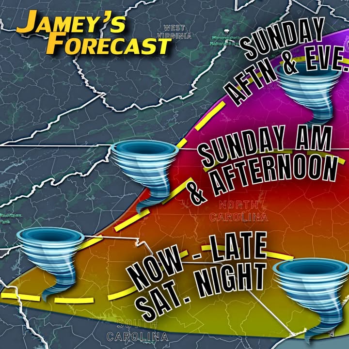
HEADS UP TONIGHT AND SUNDAY! A Special Alert for High-Impact Tornado Potential with Isaias is already verifying in central South Carolina tonight and the same conditions will be surging closer by Sunday morning into Sunday afternoon and evening for many of you.
It’s all going to come down to exactly where warm and buoyant, purely tropical air from the south will collide with a early spring-like cool air wedge, nearly anchored to the ground due to it’s higher density across most of the area tonight.
The precise orientation of the warm front is going to be critical in where rapidly intensifying storms will develop a “twisting” motion now through Sunday evening.
I’ve shown the warm front’s expected location on the map as the dashed yellow line based on my latest analysis of the computer model data combined with local research.
We already have confirmed tornadoes on the ground near Columbia, South Carolina, a location we anticipated as being in the target zone in our prediction last night because of the warm frontal location.
As we head into the rest of your Saturday night, a powerful jet stream blowing to the north and a large high pressure dome to our east will effectively FORCE the muggy tropical air to continue to battle it out through the Carolinas… —->>> then into Virginia Sunday.
By early morning, part of our area (Virginia) should see the approach of the all-important warm front and battle of NE to SE wind directions merge with a dry slot or air and a surface boundary pushing west, acting as a “zipper” to tie the wind directions together.
By Sunday morning and afternoon the triple point of all the different air masses will have its own inherent broad rotation already in progress and that all important warm front will be pushing up through many of your neighborhoods, reaching near I-64 by Sunday evening.
For anyone new here, I’m a degreed meteorologist with over 30 years of local experience in SW and West-Central Virginia. I’ve worked for a number of local television news stations over the past three decades. Much of my work includes reporting in the field from a number of hurricanes, including Katrina, Ivan, Isabel, Charley, Dorian, Irma, to name a few.
My local independent research and pattern recognition signals a heightened tornado threat for part of our area, from both the inherent tropical wind shear to the east of the center of Isaias and the colliding winds along the approaching warm front with the edge of the wedge.
If these sound like “war” terms, they are! Essentially we have a winter like pattern competing with some of the richest, moisture-laden air on the planet! There will be a true battle of sorts moving north with time through the night ahead and into much of Sunday.
To be clear, while the factors are in a favorable position and the setup is matching many precious events, keep in mind that there are small scale timing and placement issues and lots of moving parts in meteorology. My job, however is to let you know when danger could be on the way and we are moving in that direction tonight.
Stay weather aware in the shaded areas especially tonight through Sunday!
Original Facebook source: Open post
Source note: Star News TV · Oct 10, 2026 11:10 PM.
Community
Discussion
No comments yet. Be the first to respond to this report.