

GetStarNews GetStarNews
Sign In
Live
Martinsville Desk

Distillery

7:40 a.m. FRI - 11/20/26 - …FLAKES MAY FALL FOR THANKSGIVING, BUT THIS IS AN ELEVATION EVENT (as of right now)…

WeatherCategory
PUBLICVisibility
facebook_postSource type
PublishedStory status

7:40 a.m.

facebook.com | Nov 20, 2026 12:55 PM

7:40 a.m. FRI - 11/20/26 - …FLAKES MAY FALL FOR THANKSGIVING, BUT THIS IS AN ELEVATION EVENT (as of right now)…

Let’s clear something up about Thanksgiving week—because talking about snow in Virginia doesn't automatically mean we're getting buried. 😂 Still this is a fun pattern and we need moisture so it’s worth talking about! And talking about the forecast doesn’t make it “hype”.

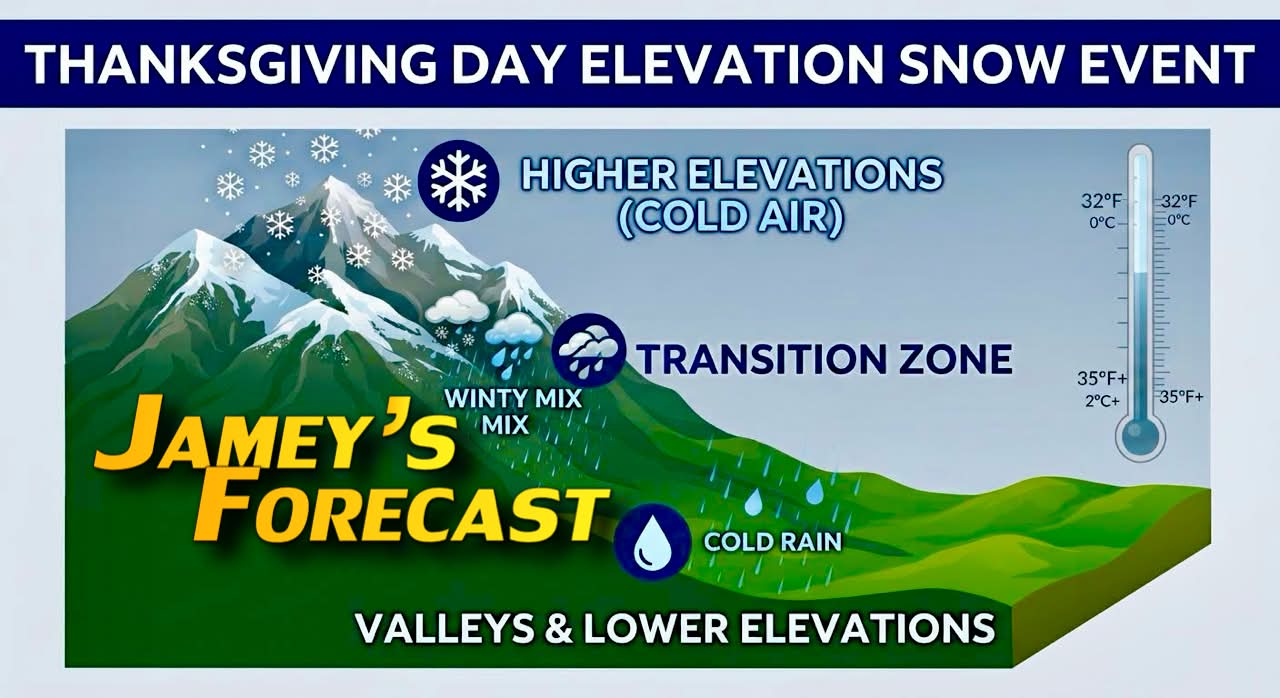
There’s a big difference between a widespread, major winter storm and an elevation snow event, and that’s exactly what I’m tracking for Wednesday into Thursday (and again next weekend).

For big snow area-wide you need cold air already in place ahead of the moisture. Our Wed-Thu system will be moving in just as the cold air is moving into the mountains. This happens again Saturday and Sunday. The air isn’t going to be super cold but just cold enough in spots for a wet snow or a rain/snow mix in lower foothills.

Here is what is actually happening:

• The Setup: El Niño-fueled moisture is moving in to meet cold—but not arctic—air oozing south into West Virginia and the western Virginia mountains. Meanwhile, part of the Polar Vortex will continue to edge south, creeping into the NE US and Ohio Valley.

• What It Means: In the valleys and lower elevations, this is mostly a cold rain, though a brief mix or "white rain" isn't out of the question.

• Who Sees Snow: If you’re headed into the higher elevations for the holiday, expect wet snow to mix in with limited, slushy accumulations. Some legit snowfall is possible however in the Greenbrier Valley of West Virginia into the Alleghenies but totals may vary depending on the temperatures.

As always this can change, so any tiny timing differences or temperature changes may alter the resulting forecast drastically. I’ll keep you ahead of whatever happens as always.

After over three decades of tracking these exact patterns here, I’m not here to hype up a blockbuster storm that isn't coming. But I do think you should know the real-world breakdown of ANY threat and impact so you aren't caught off guard on the mountain passes! ❄️

The active pattern continues into the following weekend into December. As colder air lingers, we will be riding a line between moisture and cold that bears watching the next few weeks.

Original Facebook source: Open post

Source note: Star News TV · Nov 20, 2026 12:55 PM.

Source Record

Source facebook.com
Star News TV
7:40 a.m. FRI - 11/20/26 - …FLAKES MAY FALL FOR THANKSGIVING, BUT THIS IS AN ELEVATION EVENT (as of right now)… Let’s clear something up about Thanksgiving week—because talking about snow in Virginia doesn't automatically mean we're getting buried. 😂 Still this is a fun pattern and we need moisture so it’s worth talking about! And talking about the forecast doesn’t make it “hype”. There’s a big difference between a widespread, major winter storm and an elevation snow event, and that’s exactly what I’m tracking for Wednesday into Thursday (and again next weekend). For big snow area-wide you need cold air already in place ahead of the moisture. Our Wed-Thu system will be moving in just as the cold air is moving into the mountains. This happens again Saturday and Sunday. The air isn’t going to be super cold but just cold enough in spots for a wet snow or a rain/snow mix in lower foothills. Here is what is actually happening: • The Setup: El Niño-fueled moisture is moving in to meet cold—but not arctic—air oozing south into West Virginia and the western Virginia mountains. Meanwhile, part of the Polar Vortex will continue to edge south, creeping into the NE US and Ohio Valley. • What It Means: In the valleys and lower elevations, this is mostly a cold rain, though a brief mix or "white rain" isn't out of the question. • Who Sees Snow: If you’re headed into the higher elevations for the holiday, expect wet snow to mix in with limited, slushy accumulations. Some legit snowfall is possible however in the Greenbrier Valley of West Virginia into the Alleghenies but totals may vary depending on the temperatures. As always this can change, so any tiny timing differences or temperature changes may alter the resulting forecast drastically. I’ll keep you ahead of whatever happens as always. After over three decades of tracking these exact patterns here, I’m not here to hype up a blockbuster storm that isn't coming. But I do think you should know the real-world breakdown of ANY threat and impact so you aren't caught off guard on the mountain passes! ❄️ The active pattern continues into the following weekend into December. As colder air lingers, we will be riding a line between moisture and cold that bears watching the next few weeks.
Source ref: 294815822133_1672711154871226
Martinsville MartinsvilleLocalDesk CentralDesk Facebook Starnewstv

Discussion

No comments yet. The first comment here will also become the first public forum reply for this knowledge entry.
Sign up or log in to comment and open the public thread.