

GetStarNews GetStarNews
Sign In
Live
Martinsville Desk

Distillery

8:48 p.m. FRI - 9/25/26 - TRENDING CLOSER to VIRGINIA? Sponsored by The Kingery Team at Mountain to Lake Realty 540-420-2030 BillyKingery.com It’s not out of the question! This ...

WeatherCategory
PUBLICVisibility
facebook_postSource type
PublishedStory status

8:48 p.m. FRI - 9/25/26 - TRENDING CLOSER to VIRGINIA?

facebook.com | Sep 26, 2026 1:02 AM

8:48 p.m. FRI - 9/25/26 - TRENDING CLOSER to VIRGINIA?

Sponsored by The Kingery Team at Mountain to Lake Realty 540-420-2030 BillyKingery.com

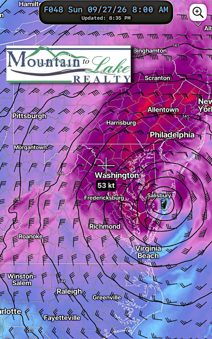
It’s not out of the question! This powerful Nor’Easter is heading into an area directly in between one jet stream to the north and another well to the south. In the middle the storm sits with its own inherent circulation.

This means two things: 1️⃣ Any movement will take some time. We may still be tracking this storm Monday of next week. 2️⃣ Small eddies from any direction could actually make a big difference in the track just like blowing on a spinning top can do.

The overall zone to watch is shifting south and west especially for Sunday into Monday. One possible model solution is shown, illustrating the winds at 5,000 feet just above the surface Sunday. This is just one of many solutions.

Keep in mind whatever the track the effects are FAR AND WIDE since the storm is extratropical. Gusty strong winds and rain can impact locations well beyond the central circulation!

Stay tuned!

Original Facebook source: Open post

Source note: Star News TV · Sep 26, 2026 1:02 AM.

Source Record

Source facebook.com
Star News TV
8:48 p.m. FRI - 9/25/26 - TRENDING CLOSER to VIRGINIA? Sponsored by The Kingery Team at Mountain to Lake Realty 540-420-2030 BillyKingery.com It’s not out of the question! This powerful Nor’Easter is heading into an area directly in between one jet stream to the north and another well to the south. In the middle the storm sits with its own inherent circulation. This means two things: 1️⃣ Any movement will take some time. We may still be tracking this storm Monday of next week. 2️⃣ Small eddies from any direction could actually make a big difference in the track just like blowing on a spinning top can do. The overall zone to watch is shifting south and west especially for Sunday into Monday. One possible model solution is shown, illustrating the winds at 5,000 feet just above the surface Sunday. This is just one of many solutions. Keep in mind whatever the track the effects are FAR AND WIDE since the storm is extratropical. Gusty strong winds and rain can impact locations well beyond the central circulation! Stay tuned!
Source ref: 294815822133_1611986127610396
Martinsville MartinsvilleLocalDesk CentralDesk Facebook Starnewstv

Discussion

No comments yet. The first comment here will also become the first public forum reply for this knowledge entry.
Sign up or log in to comment and open the public thread.